


An area of low pressure is set to bring stormy weather – including winds of up to 80mph – to the UK after it crosses the Atlantic Ocean.
The low pressure area will see jet stream winds approaching 200mph on Saturday as it crosses the Atlantic.
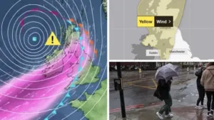
The Met Office said this area will then undergo “explosive” deepening as it nears the UK and Ireland on Sunday.
They added this will bring damaging winds, most likely in the northern and western areas through Sunday and possibly into Monday.
The forecaster said this could bring disruption and has warned motorists to be careful drving during high winds due to potentially “hazardous” conditions.
The Met Office added that a windy period is expected across the whole of the UK on Sunday and into Monday.
A yellow weather warning for wind has also been issued from 3am on Sunday until Monday midday.
Across parts of Scotland, Northern Ireland, Northwest England and North West Wales there is an increased chance of some disruption.


They added that a period of strong south to southeasterly winds will likely develop through Sunday morning, with gusts of 50-60 mph possible in some inland areas, especially Northern Ireland and western Scotland, and perhaps up to 60-70 mph along exposed coasts and hills.
Winds will then likely turn southwesterly, with a period of especially strong winds possible during Sunday afternoon and evening in western Scotland where gusts could potentially reach 70-80 mph in exposed areas, and more generally 55-65 mph in other parts of the warning area.
These strong winds in conjunction with high spring tides may cause some disruption.


“Initially a period of strong south to southeasterly winds will likely develop through Sunday morning, with gusts of 50-60mph possible in some inland areas, especially Northern Ireland and western Scotland, and perhaps up to 60-70mph along exposed coasts and hills.
“Winds will then likely turn southwesterly, with a period of especially strong winds possible during Sunday afternoon and evening in western Scotland, where gusts could potentially reach 70-80mph in exposed areas, and more generally 55-65mph in other parts of the warning area.
“These strong winds in conjunction with high spring tides, may cause some disruption.
“It’s likely that Sunday’s wind warning will be updated and refined as confidence increases, and more warnings for the rainfall that is expected is likely. It is therefore important people stay up to date with the latest forecast.”


‘Hazardous’
RAC Breakdown spokesperson Alice Simpson said: “This latest bout of stormy autumnal weather is likely to make driving conditions hazardous this weekend, especially for drivers in the north and west of the UK.
“Strong winds will demand motorists keep a good grip of the steering wheel and allow plenty of space between themselves and the vehicle in front, so they are able to react quickly to whatever they see up ahead.
“We also strongly advise avoiding exposed routes, especially those close to coasts that are likely to see the biggest effects from the gusts and where particularly high spring tides could lead to some roads becoming flooded.”
By Flaminia Luck